
Comparing French Polynesia and U.S. Territories
Dr. Roger W. Anderson, Independent Scholar
Find the world map hanging in your school. Does it:
- display North America above South America and Europe atop a Mediterranean saddle over Africa?
- center Europe or the Atlantic Ocean, positioning Japan on the far right and Hawaii on the far left?
This is the most common (political) world map and most common way it is mounted on walls within American schools, from my observation.
Yet only those with knowledge of how planet Earth is suspended in the universe could say if our maps are hung properly or upside-down.
Absent such cosmic knowledge, I wonder why educators, who are among the most educated Americans, continue this practice. Because the northern hemisphere contains more landmass, and thus more humans? Because the Pacific Ocean is the least-offensive victim when rendering a three-dimensional body into a two-dimensional one ?
I suspect that most educators are simply following tradition for fear of appearing unintelligent, or worse, appearing to be rocking the boat.
Do maps matter?
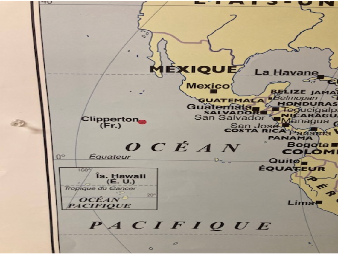
Only upon my return from a Tahitian vacation did I notice that Tahiti and French Polynesia, which encompasses it, were left off the map in my hallway. The map purports to identify Francophone polities.
Despite its location in the south Pacific, three thousand miles from New Zealand and 5,000 miles from Chile, Tahiti is located on the Americas’ side of the International Date Line. Despite Tahiti’s absence, the equally remote archipelago of Hawaii is present. Hawaii was a Polynesian country from 1795-1893. More curious, Clipperton Island, a French territory which is much smaller than Tahiti but uninhabited, was also included. But no French Polynesia.
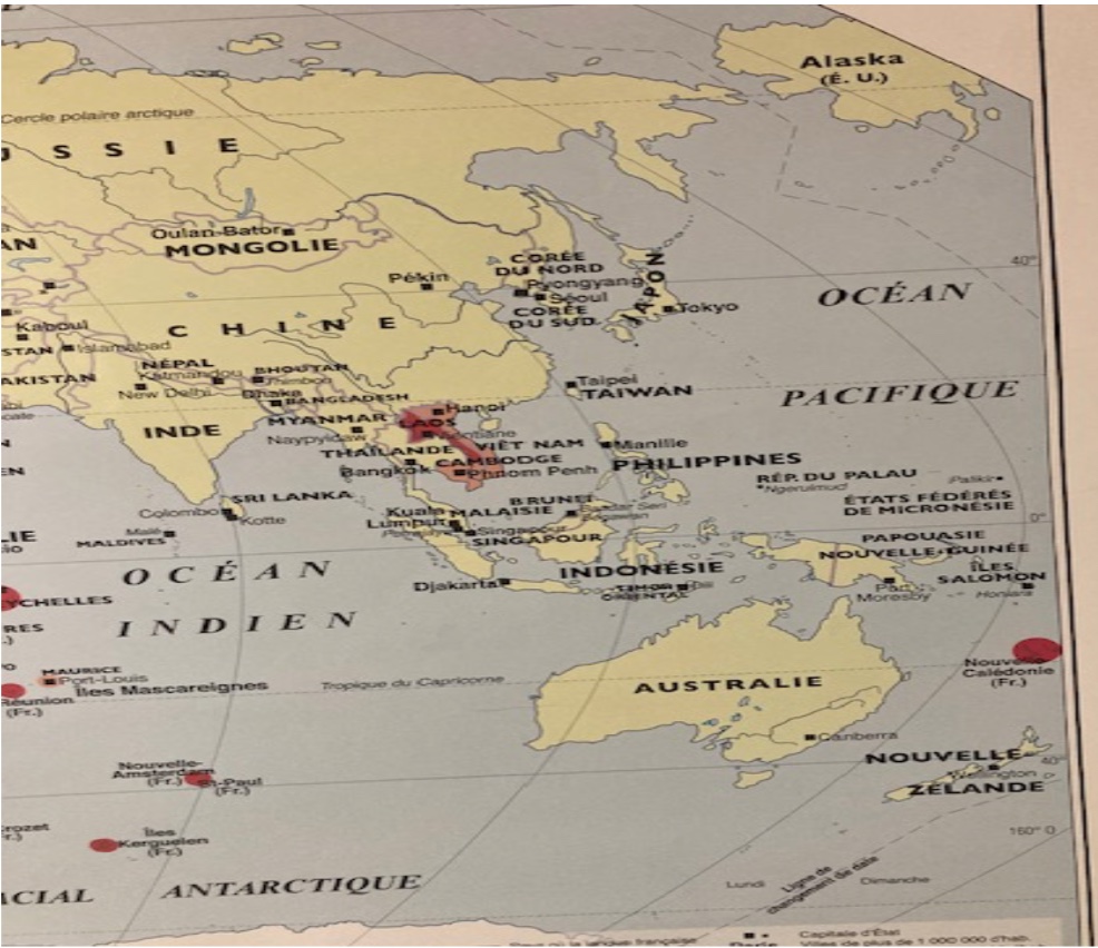
Not on the right side of the map, northeast of New Zealand –where it should be. See Image 2.
In Disney’s 2024 film Moana 2, it is an angry god that separated the peoples of the Pacific. Yet in my hallway, map-makers exact a worse injustice.
The Political Rights of Citizens
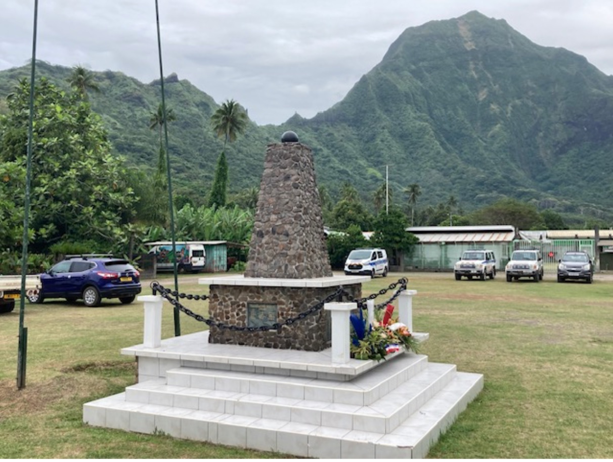
Tahiti belongs to French Polynesia, whose citizens are French citizens. (See Image 3.) Totaling 300,000 inhabitants, this semi-autonomous territory is comprised of nearly two hundred islands spread over an ocean expanse larger than Europe.
French Polynesia is a French overseas territory. All of the nearly three million French citizens living in France’s twelve overseas departments and territories (DOM-TOMs) are afforded full civil and political rights, including representation in France’s Parliament. Due to the DOM-TOMs’ far-flung locations, France remains the country with the greatest number of time zones (WorldAtlas.com, 2024). See Image 4.

On my hallway’s map, French Polynesia’s vastness is reduced to the size of Martinique. Both are footnotes to metropolitan France.
The rights of French citizens in territories differ starkly from U.S. citizens living in the five U.S. territories: Puerto Rico, Guam, American Samoa, Northern Mariana Islands, and U.S. Virgin Islands. American citizens from the territories are not represented in the House of Representatives or U.S. Senate, nor do they receive any Electoral College votes—meaning that they have no voice in electing the U.S. President. Only states have this right, as well as Washington D.C. since the 1961 passage of the 23rd Amendment.
More U.S. citizens live in these five territories than in the five least-populated states combined (Vermont, Wyoming, Alaska, North & South Dakota). The American Civil Liberties Union advocates for the granting of full political rights to the inhabitants of these “modern-day colonies.”
These statistics exclude Washington, D.C., whose population is greater than that of two U.S. states. Washingtonians also pay more in federal taxes than 21 states (Sprunt, 2021). Yet Washingtonians have no voice in the U.S. government—the government that taxes them and can draft them into war.
This arrangement is antithetical to democracy and a blot on the reputation of the nation that sees itself as a global exemplar of democracy.
Palau, the world’s most recently-decolonized nation, only gained independence in 1994 from the United States (United Nations, 2024). Check your map, as it too may have been swallowed by the Pacific Ocean.
Classroom Ideas: Flip Your Map, Contextualize Democratic Rights
Many educators know the adage, “Education is not the filling of a pail but the lighting of a fire.” They encourage students to never stop questioning, collecting facts and perspectives, nor reformulating their understanding.
Reorienting your classroom map, or displaying one that decenters Europe, will spark curiosity. It may even shake up stale, racially-tinged assumptions about the Global South vis-à-vis the Global North. Moreover, educators can develop students’ intercultural competence and civic knowledge by facilitating comparisons of U.S. citizenry with those of other countries and territories. For example, contrast the rights that Ohioans possess that fellow U.S. citizens in Guam do not. Privilege is relative, and Ohioans are privileged relative to their compatriots in the territories.
Tahitians may be left off maps, but they are not left out of French democracy. If I were a Tahitian educator, my classroom’s global map would not center on Europe. If I were a Puerto Rican or Washingtonian educator, my map would not be the conventional one, conventionally hung. Nor would I “beg for my rights” (Turner, 2006). In the twenty-first century, no American citizen should be made to suffer the indignity of second-class citizenship.
References
ACLU (2024). Anti-Colonialism. Retrieved Oct. 25, 2024, from https://www.aclu.org/issues/racial-justice/anti-colonialism#:~:text=As%20we%20assess%20the%20relationship,them%20and%20remain%20so%20today
Sprunt, B. (2021, ). House Democrats Pass Bill To Make D.C. The 51st State. Npr https://www.npr.org/2021/04/22/989119412/house-democrats-pass-bill-to-make-d-c-the-51st-state
Turner, H. M. (2006). I shall not beg for my rights. In Davis, A.; Lynn, E. (Eds.). The Civically Engaged Reader: A diverse collection of short, provocative readings on civic activity. Great Books Foundation. pp. 148-156.
United Nations. (2024). Decolonization. Retrieved Oct. 25, 2024 from https://www.un.org/en/globalissues/decolonization#:~:text=The%20Trust%20Territory%20of%20the,association%20with%20the%20United%20States.
WorldAtlas.com. (2023, Jan. 5). 10 Countries With The Most Time Zones. Retrieved Nov 22, 2024, from https://www.worldatlas.com/time-zones/10-countries-with-the-most-time-zones.html
